


US Topo Maps
Deskripsi US Topo Maps
Aplikasi navigasi luar ruangan yang mudah digunakan dengan akses gratis ke peta dan citra udara terbaik yang tersedia untuk AS.
Pilih antara 30+ lapisan peta (topos, antena, peta laut, ...) untuk merencanakan perjalanan dan perjalanan yang sempurna
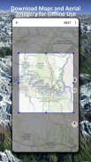
ubah Ponsel/Tablet Andoid Anda menjadi GPS luar ruangan untuk perjalanan offline ke pedalaman.
Tambahkan peta dengan mudah dari sumber lain (GeoPDF, GeoTiff, Layanan Peta Online seperti WMS, ...)
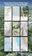
Lapisan peta dasar yang tersedia untuk AS:
• Peta Nasional USGS Topo
• Citra Peta Nasional USGS Topo
• Citra Peta Nasional USGS
• Citra Perekrutan USGS NAIP
• DRG tradisional USGS Topo: Cakupan peta topo AS yang mulus pada Skala 1:250.000, 1:100.000, 1:63.000, dan 1:24.000/25.000
• Peta Hutan FSTopo
• Peta RNC Bahari NOAA
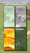
• Peta Ketinggian Nasional (Hillshade, Peta Kemiringan, Peta Aspek)
Lapisan peta dasar seluruh dunia:
• OpenStreetMaps (5 tata letak peta berbeda), juga dapat diunduh dalam format vektor yang menghemat ruang
• Google Maps (Gambar satelit, Peta Jalan dan Medan)
• Bing Maps (Gambar satelit, Peta Jalan)
• Bumi Di Malam Hari
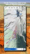
Konfigurasikan lapisan peta dasar sebagai overlay dan manfaatkan fader transparansi untuk membandingkan peta satu sama lain dengan lancar.
Tambahkan peta dari sumber lain:
• Impor peta raster dalam GeoPDF, GeoTiff, MBTiles atau Ozi (Oziexplorer OZF2 & OZF3)
• Tambahkan layanan pemetaan web sebagai WMS atau WMTS/Tileserver
• Impor OpenStreetMaps dalam format Vektor, misalnya USA lengkap hanya untuk beberapa GB
Hamparan peta AS yang tersedia - tambahkan informasi tambahan ke peta dasar lainnya:
• Kepemilikan Tanah Publik (PAD-US 3)
• Kumpulan Data Hidrografi Nasional
• Peta Penggunaan Kendaraan Bermotor (USDA)
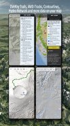
• Garis Kontur Ketinggian
• Jalur 4WD
• Jalur
• Jalan, Rel Kereta Api, Bandara
Hamparan yang tersedia di seluruh dunia:
• Hamparan bayangan bukit
• Garis Kontur 20m
• OpenSeaMap
Tidak ada peta yang sempurna. Beralih di antara lapisan peta yang berbeda atau gunakan fitur bandingkan peta untuk menemukan rute yang paling menarik. Terutama DRG tradisional lama yang mengandung banyak jalur kecil atau fitur lain yang tidak ada di peta modern.
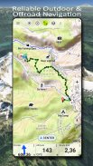
Fitur utama untuk navigasi luar ruangan:
• Unduh data peta untuk PENGGUNAAN OFFLINE
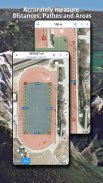
• Ukur jalur dan area
• Membuat dan mengedit Titik Arah
• Navigasi GoTo-Waypoint
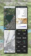
• Membuat dan mengedit Rute
• Navigasi Rute (Navigasi Titik-ke-Titik)
• Perekaman Lintasan (dengan profil kecepatan, ketinggian, dan akurasi)
• Tripmaster dengan kolom untuk odometer, kecepatan rata-rata, arah, ketinggian, dll.
• Impor/Ekspor GPX/KML/KMZ
• Pencarian (nama tempat, POI, jalan)
• Dapatkan ketinggian dan jarak
• Bidang data yang dapat disesuaikan dalam Tampilan Peta dan Tripmaster (misalnya Kecepatan, Jarak, Kompas, ...)
• Bagikan Titik Arah, Lintasan, atau Rute (melalui email, Dropbox, WhatsApp, ..)
• Gunakan koordinat di WGS84, UTM atau MGRS/USNG (Military Grid/ US National Grid),
• Putar Ulang Lagu
• dan masih banyak lagi ...
Gunakan aplikasi navigasi ini untuk aktivitas luar ruangan seperti hiking, bersepeda, berkemah, memanjat, berkuda, ski, kano, berburu, tur mobil salju, tur 4WD offroad, atau pencarian & penyelamatan (SAR).
Tambahkan titik jalan khusus dalam format bujur/lintang, UTM atau MGRS/USNG dengan datum WGS84.
Impor/Ekspor/Bagikan Titik Arah/Trek/Rute GPS dalam format GPX atau Google Earth KML/KMZ.
Lihat animasi radar hujan NEXRAD untuk membuat prediksi akurat kapan hujan akan mulai/berhenti
Silakan kirim pertanyaan, komentar, dan permintaan fitur ke support@atlogis.com
US Topo Maps - Versi 7.8.0
(08-05-2025)US Topo Maps - Informasi APK
Versi APK: 7.8.0Paket: com.atlogis.northamerica.freeVersi Terakhir dari US Topo Maps
Versi lain


 4.63
4.63


 4.15
4.15
Aplikasi pada kategori yang sama


Anda juga mungkin suka...
Aplikasi pada kategori yang sama


